Welcome
GeoSurv is a geophysical survey company that specialises in gathering data in the nearshore environment including land based topographic and coastal erosion surveys. We have strong links with the University of St. Andrews which has gained international recognition as a centre of excellence.
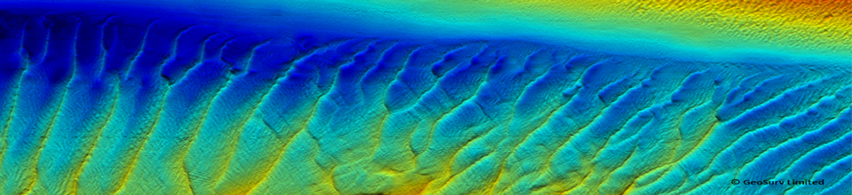
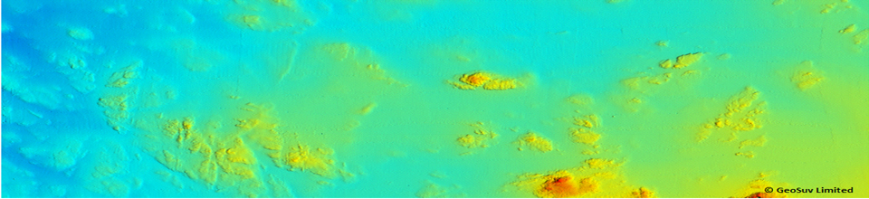
GeoSurv operates an inshore survey vessel which is equipped with a 468 kHz SEA SwathPlus interferometric multibeam, DMS-05 motion reference unit and Trimble RTK GPS system. Based out of Tayport, Scotland, the vessel is road transportabler allowing rapid mobilisation to site.
.
January 22, 2014
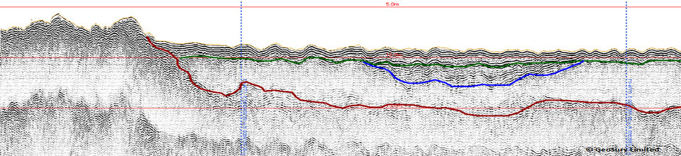
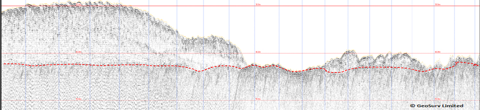
GeoSurv conducted a sub-bottom profiler data processing and interpretation exercise for a third party tidal developer for a site off the English south coast. A final report and charts were produced with an assessment of the data quality provided and [...]
GeoSurv was contacted by Marine Current Turbines in December 2013 to conduct an assessment of data suitability gathered over a number of years for MCT by third party contractors. Various GIS and geophysical software applications were employed in order to critically [...]
GeoSurv was contracted as a Team Leader within the Geoscience Department overseeing the deliverables (reports and charts) for a number of TOTAL Ltd. Projects within the North Sea.
April 26, 2013
GeoSurv Limited have been providing an on going service to OMM since September 2012. Projects include conducting and overseeing a beach topographic and diver wade survey in Anglesey and data analysis/ report writing on the Forewind, Dogger Bank wind farm [...]
GeoSurv Limited was asked to conduct a desktop study of geophysical data for Marine Current Turbines (MCT) site within the Skerries, Anglesey. The objective was to determine further survey requirements for a cable route and also to map geological features [...]
January 8, 2013
GeoSurv in collaboration with SOi Limited conducted a Swath bathymetry survey of the harbour and entrance channel at Arbroath, utilising a SEAswath system (468kHz) and a Trimble R6 RTK VRS positioning system. The survey was completed using the Zego 2 man [...]
June 19, 2012
We are delighted to announce the move to new premises within Edinburgh City. Following on from the award of new contracts it was deemed necessary to move into a larger office space where processing and reporting could be undertaken in [...]
GeoSurv Limited are delighted to announce the award of a geophysical survey by the State of Jersey. The survey involves utilising a Geoswath Plus bathymetric system and Pinger sub-bottom profiler to investigate the seabed within St Aubin Bay and La Greve D’Azette as [...]
GeoSurv were delighted to be contracted by SOi Limited to undertake a bathymetric and backscatter survey of Montrose Bay for Angus Council. Utilising the Geoacoustics Geoswath Plus interferometric system and RTK positioning from a Trimble R6 VRS receiver proved a real [...]
September 27, 2011
Pelamis Wave Power in conjunction with Marine Scotland contracted GeoSurv Limited and our partner Scottish Oceans Institute (SOi Ltd.) to provide a sub-bottom profiling capability for soil investigations off Shetland. The joint venture utilised Marine Scotland’s research vessel the Alba [...]
Switch to our mobile site